Traditional ground surveying in open-pit mines relies on manual rovers and total stations, exposing field crews to dangerous highwalls while creating severe data turnaround delays. Modern mining enterprises are adopting high-precision spatial technology to automate mapping and protect personnel. Industry innovators like Icecypress Technology deliver end-to-end 3D spatial vision solutions that transform raw aerial feeds into actionable operational intelligence for heavy industrial environments.
Deploying a Mining Monitoring System for Sub-Meter Spatial Accuracy
High-precision mapping across open-pit concessions demands rigorous spatial accuracy. Volumetric auditing, pit expansion monitoring, and overburden removal require accurate spatial data to prevent costly accounting discrepancies and operational delays to prevent costly accounting discrepancies and operational delays. Manual measurement across unstable terrain fails to provide the spatial density required for dynamic site management.
Achieving continuous and accurate monitoring across large extraction sites requires automated data collection and 3D modeling. Icecypress’s digital twin mine solution combines drones with its self-developed Mirauge3D software to automate data collection and generate 3D models. This reduces reliance on manual surveying while providing high-frequency spatial data for monitoring changing mine conditions.
Deploying an integrated mining monitoring system enables mine operators to automate data collection and 3D modeling while maintaining continuous visibility into changing site conditions. The solution combines drone surveying, Mirauge3D, AI, IoT, and 5G cloud services to support real-time monitoring across terrain, production, equipment, and safety operations.
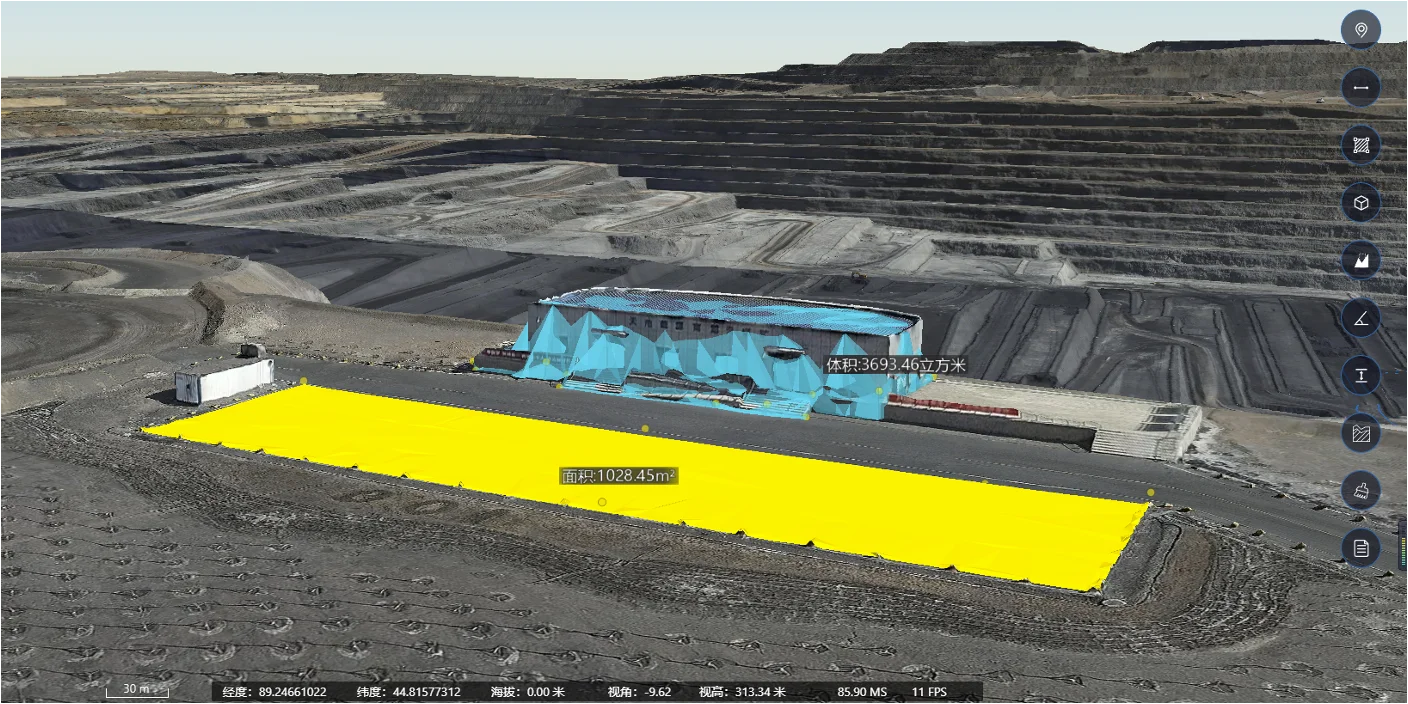
Continuous drone-based data collection also supports spatial measurement and production planning. The platform can measure the area, volume, and length of stockpiles and pits, while multi-phase drone imagery can be used to monitor ore-volume changes and support production planning and resource scheduling. For safety management, 3D model comparisons can identify deformation beyond defined thresholds and support proactive slope stability alerts.
Financial Impact: Cost Optimization and Risk Mitigation
Integrating autonomous UAV workflows into mining operations delivers quantifiable cost reductions by shortening survey cycles, eliminating surveyor exposure to extraction zones, and preventing machinery downtime during survey sweeps. Rapid spatial data acquisition dramatically lowers overall operating costs across large-scale industrial properties.
Cost optimization comes from reducing manual survey work, improving planning efficiency, and supporting predictive maintenance. The platform uses 3D maps to optimize transport routes according to slope and distance parameters, helping reduce cutting time and fuel costs. Its AI and IoT capabilities also support predictive maintenance, helping operators move from reactive repairs toward more planned equipment management.
By eliminating manual surveying in hazardous areas, industrial mine operators mitigate severe occupational safety risks. Remote aerial data collection keeps field technicians away from active blasting zones, uncontained rockfalls, and heavy haulage traffic. Keeping personnel out of harm’s way directly reduces liability costs and improves overall site safety metrics.
Best Practices for Enterprise Implementation
To maximize return on investment and maintain strict data integrity, industrial mining operators should establish standardized automated flight paths across routine survey cycles. Utilizing pre-programmed grid flights maintains consistent ground sampling distances across expansive pit concessions, ensuring repeatable volumetric measurements over long operational periods.
Another practical consideration is the frequency and consistency of data collection. Repeated drone surveys can create comparable datasets for tracking changes over time, allowing mine managers to evaluate production progress, site development, and safety conditions from the same spatial reference. When these datasets are connected with operational information, teams can make planning decisions based on current site conditions rather than isolated survey results. This approach also supports more consistent communication between surveying, production, safety, and management teams.
Safety and environmental management are also important parts of a digital mine workflow. Drone-based 3D modeling can support hydrological analysis by helping operators simulate water and tailings flow and evaluate potential changes in mine water conditions. This provides additional information for mine design, construction planning, and disaster risk management. The system can also support dump-site electronic fencing and real-time vehicle positioning. By monitoring vehicle locations and defining restricted areas, mine operators can improve traffic management and reduce the risk of vehicle conflicts in busy extraction zones. These functions extend drone surveying beyond periodic mapping, making spatial data useful for both environmental planning and daily safety management.
A centralized digital twin can also connect production, equipment, scheduling, and IoT data within one management environment. The operation center provides real-time data updates, production capacity management, equipment information and maintenance records, as well as equipment status and ETA data for scheduling. This gives mine managers a more unified view of day-to-day operations.
Strategic Value in Industrial Mining Operations
As low-altitude spatial technology matures, automated aerial surveying is transitioning from an auxiliary tool into essential enterprise infrastructure for the modern mining industry. Standardizing high-precision aerial workflows enables mine operators to achieve unprecedented operational visibility, improved cost efficiency, and total field crew safety.
Enterprise mining authorities and industrial operators seeking to upgrade their site digitalization capabilities can reach out to the technical team at Icecypress Technology to implement tailored smart mining solutions.
