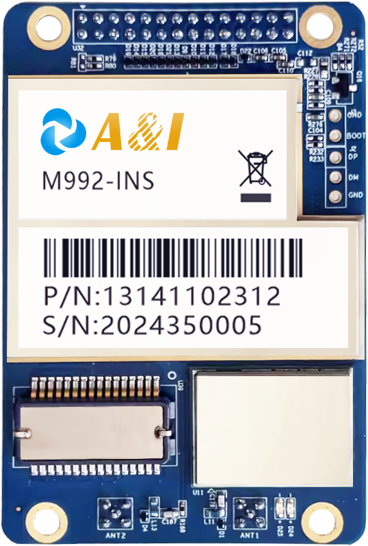
Modern outdoor automation demands absolute spatial certainty across sprawling agricultural fields and complex surveying job sites. Achieving centimeter-level positioning precision requires robust satellite signal processing to eliminate atmospheric interference completely. Equipment manufacturers rely heavily on advanced hardware to keep robotic systems securely on track and operating efficiently under dynamic conditions.
Outdoor environments present unique signal propagation challenges due to dense tree canopies, open terrain variations, and undulating elevation profiles. Selecting appropriate positioning technology directly influences the operational success and long-term profitability of modern robotic fleets. Hardware designers continuously refine receiver architectures to meet these demanding industrial requirements and maintain high availability.
Precision Agriculture Machinery and Autonomous Field Robots
Farming operations increasingly depend on automated machinery to execute precise planting, fertilizing, and mechanical weeding tasks without human intervention. Smart tractors utilize high-accuracy tracking to minimize overlap and reduce chemical waste across vast acreage. Integrating a dual band GNSS receiver allows these heavy-duty machines to correct ionospheric errors instantly.
Row-crop cultivation requires sub-decimeter repeatability over entire growing seasons without requiring constant manual steering adjustments from human operators. Autonomous harvesters and seeding rigs leverage robust guidance modules mounted directly on the vehicle frame. Survey-grade positioning ensures that every operational pass aligns perfectly with pre-planned digital field maps.
Crop spraying applications benefit enormously from real-time spatial accuracy to prevent costly over-application near sensitive environmental protection zones. Automated spray booms adjust fluid output dynamically based on exact vehicle coordinates received from onboard positioning hardware. Operational efficiency rises while chemical input costs drop significantly for commercial growers worldwide.
Unmanned Ground Vehicles and Heavy Field Automation
Unmanned ground vehicles operating in rugged terrain require uninterrupted spatial orientation to navigate safely past unexpected obstacles. Heavy robotic transports deployed in open-pit mining or large construction zones rely on a specialized navigation board to process multiple satellite frequencies simultaneously. Continuous data streams prevent catastrophic drift during extended operational shifts.
Dynamic path planning algorithms depend on reliable velocity and heading data supplied by onboard inertial measurement units and satellite sensors. Autonomous utility vehicles maintain tight trajectory tolerances even when satellite visibility drops temporarily near steep embankments or physical structures. Uncompromising signal reliability protects expensive equipment from accidental collisions across difficult terrains.
Ruggedized positioning hardware engineered by Archimedes Innovation withstands severe vibration, dust, and moisture extremes in the field. Their advanced manufacturing protocols ensure that field electronics maintain calibration across thousands of hours of continuous operation. Fleet managers trust these robust systems to deliver dependable performance day after day.
Professional Land Surveying and Geodetic Mapping
Land surveyors demand absolute legal accuracy when establishing property boundaries, topographic contours, and civil infrastructure layouts across challenging landscapes. Geodetic rovers utilizing dual band GNSS technology resolve integer ambiguities rapidly, cutting down setup times on active job sites. Field crews complete complex boundary surveys faster without sacrificing measurement integrity.
Topographic mapping projects require continuous data logging across diverse geographical terrains ranging from dense forests to wide-open plains. Modern survey poles equipped with multi-constellation receivers capture accurate elevation data despite partial sky obstructions. Reliable spatial coordinates streamline the creation of high-definition digital terrain models for civil engineers.
Construction staking relies on exact coordinate transfer from office engineering models directly to the physical job site with zero tolerance for error. Surveyors use advanced positioning tools to stake out building corners, utility trenches, and roadway alignments with millimeter precision. Eliminating layout errors early prevents costly rework during subsequent construction phases.
Core Hardware Integration and System Reliability
System integrators face rigorous mechanical and electrical constraints when embedding positioning electronics into compact robotic enclosures and mobile rovers. Selecting a high-performance navigation board simplifies antenna integration while maintaining low power consumption profiles. Hardware efficiency directly extends operational battery life for remote field units operating off-grid.
Thermal management inside sealed equipment housings remains vital for preventing processor throttling and sensor drift during hot summer operating months. Engineering teams design specialized cooling pathways and thermal pads to protect sensitive radio frequency components from overheating. Reliable thermal performance safeguards overall system availability in harsh outdoor climates.
Engineers at Archimedes Innovation provide comprehensive technical support and modular hardware architectures tailored specifically for demanding industrial deployments worldwide. Their engineering philosophy centers on delivering seamless interoperability between satellite receivers and vehicle control units. Organizations partnering with them gain a distinct competitive edge in automated system development.
Commercial scalability depends on component reliability, ease of calibration, and long-term hardware availability for high-volume production assembly lines. Equipment manufacturers continually upgrade their platforms to leverage emerging satellite constellations and improved signal bands. Forward-thinking companies secure their market position by adopting superior positioning technologies today.
Regulatory compliance and stringent safety standards require certifiable positioning accuracy across all commercial autonomous transport and surveying platforms. Integrating robust hardware solutions ensures that every deployment meets municipal inspection criteria without delays. Project stakeholders benefit from transparent audit trails generated by verified coordinate logs.
Advanced solutions from Archimedes Innovation continue to push the boundaries of industrial positioning through rigorous testing and innovative hardware designs. Their commitment to excellence empowers agricultural and surveying sectors to achieve unprecedented levels of automation efficiency. Mastering spatial accuracy remains the ultimate catalyst for modern industrial transformation across global markets.
Future-proofing industrial fleets starts with uncompromising data integrity at the foundational hardware level. Relying on fragmented or low-accuracy positioning introduces unacceptable operational risks into automated workflows. Progressive enterprises consistently choose high-fidelity measurement protocols as their permanent operating standard for long-term success in competitive markets.
